


Union County Precinct 1, Union County, New Mexico
About
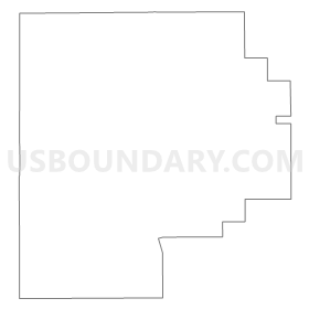
Outline
Summary
| Unique Area Identifier | 624248 |
| Name | Union County Precinct 1 |
| County | Union County |
| State | New Mexico |
| Area (square miles) | 1,129.86 |
| Land Area (square miles) | 1,128.69 |
| Water Area (square miles) | 1.17 |
| % of Land Area | 99.90 |
| % of Water Area | 0.10 |
| Latitude of the Internal Point | 36.74604760 |
| Longtitude of the Internal Point | -103.74256150 |
Maps


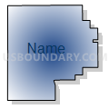
Graphs
Select a template below for downloading or customizing gragh for Union County Precinct 1, Union County, New Mexico


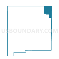
Neighbors
Neighoring Voting District (by Name) Neighboring Voting District on the Map
- Colfax County Precinct 10, Colfax County, NM
- Colfax County Precinct 22, Colfax County, NM
- Colfax County Precinct 5, Colfax County, NM
- Las Animas 2, Las Animas County, CO
- Union County Precinct 4, Union County, NM
Top 10 Neighboring County Subdivision (by Population) Neighboring County Subdivision on the Map
- Raton CCD, Colfax County, NM (8,062)
- Springer CCD, Colfax County, NM (2,213)
- Clayton North CCD, Union County, NM (819)
- Branson CCD, Las Animas County, CO (164)
Top 10 Neighboring Place (by Population) Neighboring Place on the Map
- Des Moines village, NM (143)
- Capulin CDP, NM (66)
- Folsom village, NM (56)
- Grenville village, NM (38)
Top 10 Neighboring Unified School District (by Population) Neighboring Unified School District on the Map
- Raton Public Schools, NM (7,977)
- Clayton Public Schools, NM (3,976)
- Springer Municipal Schools, NM (1,820)
- Des Moines Municipal Schools, NM (553)
- Branson Reorganized School District 82, CO (173)
Top 10 Neighboring State Legislative District Lower Chamber (by Population) Neighboring State Legislative District Lower Chamber on the Map
- State House District 64, CO (63,179)
- State House District 67, NM (25,041)
- State House District 68, NM (23,727)
Top 10 Neighboring State Legislative District Upper Chamber (by Population) Neighboring State Legislative District Upper Chamber on the Map
Top 10 Neighboring 111th Congressional District (by Population) Neighboring 111th Congressional District on the Map
Top 10 Neighboring Census Tract (by Population) Neighboring Census Tract on the Map
- Census Tract 9507, Colfax County, NM (5,688)
- Census Tract 9502, Union County, NM (4,549)
- Census Tract 9505, Colfax County, NM (4,315)
- Census Tract 8, Las Animas County, CO (2,766)
Top 10 Neighboring 5-Digit ZIP Code Tabulation Area (by Population) Neighboring 5-Digit ZIP Code Tabulation Area on the Map
- 87740, NM (8,068)
- 88415, NM (3,569)
- 88418, NM (294)
- 88419, NM (229)
- 88424, NM (128)
- 81027, CO (125)
- 88422, NM (68)
- 88414, NM (39)